
Lu Verne topographic map
Interactive map
Click on the map to display elevation.
About this map
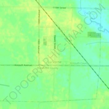
Name: Lu Verne topographic map, elevation, terrain.
Location: Lu Verne, Kossuth County, Iowa, United States (42.89909 -94.10494 42.92265 -94.06888)
Average elevation: 351 m
Minimum elevation: 340 m
Maximum elevation: 360 m
Other topographic maps
Click on a map to view its topography, its elevation and its terrain.
Algona
United States > Iowa > Kossuth County
Algona, Kossuth County, Iowa, 50511, United States
Average elevation: 361 m
West Bend
United States > Iowa > Kossuth County > West Bend
West Bend, Kossuth County, Iowa, United States
Average elevation: 360 m
Bancroft
United States > Iowa > Kossuth County
Bancroft, Kossuth County, Iowa, United States
Average elevation: 354 m