
Weeksville topographic map
Interactive map
Click on the map to display elevation.
About this map
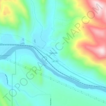
Name: Weeksville topographic map, elevation, terrain.
Location: Weeksville, Sanders County, Montana, United States (47.50222 -115.00703 47.54222 -114.96703)
Average elevation: 864 m
Minimum elevation: 731 m
Maximum elevation: 1,237 m
Other topographic maps
Click on a map to view its topography, its elevation and its terrain.
Heron
United States > Montana > Sanders County
Heron, Sanders County, Montana, United States
Average elevation: 762 m
Paradise
United States > Montana > Sanders County
Paradise, Sanders County, Montana, United States
Average elevation: 881 m
Thompson Falls
United States > Montana > Sanders County
Thompson Falls, Sanders County, Montana, 59873, United States
Average elevation: 782 m
Plains
United States > Montana > Sanders County > Plains
Plains, Sanders County, Montana, United States
Average elevation: 775 m
Thompson Falls
United States > Montana > Sanders County > Thompson Falls
Thompson Falls, Sanders County, Montana, 59873, United States
Average elevation: 897 m