
Samos topographic map
Interactive map
Click on the map to display elevation.
About this map
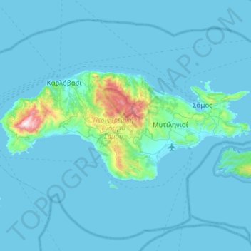
Name: Samos topographic map, elevation, terrain.
Average elevation: 78 m
Minimum elevation: -1 m
Maximum elevation: 1,421 m
Das Relief der Insel ist zu über 60 % hügelig bis bergig mit Höhen zwischen 150 und 900 Metern. Der Gebirgsanteil mit Höhen über 900 Meter beträgt mehr als vier Prozent, dabei dominieren die beiden Massive des Kerkis (Κέρκης) und des Ambelos-Gebirges (Άμπελος). Flachland und Ebenen bis 150 Meter Höhe nehmen mit fast 160 km² nahezu ein Drittel der Inselfläche ein.
Other topographic maps
Click on a map to view its topography, its elevation and its terrain.
Δημοτική Ενότητα Πυθαγορείου
Griechenland > Ägäis > Regionalbezirk Samos
Δημοτική Ενότητα Πυθαγορείου, Δήμος Ανατολικής Σάμου, Regionalbezirk Samos, Region Nördliche Ägäis, Ägäis, Griechenland
Average elevation: 220 m
Chora
Griechenland > Ägäis > Regionalbezirk Samos > Δημοτική Ενότητα Πυθαγορείου
Chora, Δημοτική Ενότητα Πυθαγορείου, Δήμος Ανατολικής Σάμου, Regionalbezirk Samos, Region Nördliche Ägäis, Ägäis, 831 03, Griechenland
Average elevation: 88 m