
Δημοτική Ενότητα Πυθαγορείου topographic map
Interactive map
Click on the map to display elevation.
About this map
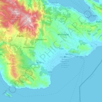
Name: Δημοτική Ενότητα Πυθαγορείου topographic map, elevation, terrain.
Average elevation: 220 m
Minimum elevation: 0 m
Maximum elevation: 1,152 m
Other topographic maps
Click on a map to view its topography, its elevation and its terrain.
Chora
Griechenland > Ägäis > Regionalbezirk Samos > Δημοτική Ενότητα Πυθαγορείου
Chora, Δημοτική Ενότητα Πυθαγορείου, Δήμος Ανατολικής Σάμου, Regionalbezirk Samos, Region Nördliche Ägäis, Ägäis, 831 03, Griechenland
Average elevation: 88 m
Samos
Griechenland > Ägäis > Regionalbezirk Samos
Samos, Regionalbezirk Samos, Region Nördliche Ägäis, Ägäis, Griechenland
Average elevation: 78 m