
Holmen topographic map
Click on the map to display elevation.
About this map
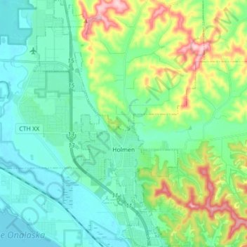
Name: Holmen topographic map, elevation, terrain.
Location: Holmen, La Crosse County, Wisconsin, United States (43.92337 -91.30767 44.02426 -91.22561)
Average elevation: 244 m
Minimum elevation: 193 m
Maximum elevation: 397 m
Other topographic maps
Click on a map to view its topography, its elevation and its terrain.
Village of West Salem
United States > Wisconsin > La Crosse County > West Salem
Average elevation: 226 m