
Nerja topographic map
Interactive map
Click on the map to display elevation.
About this map
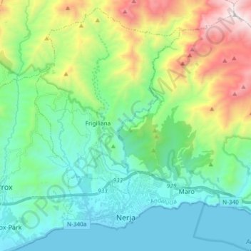
Name: Nerja topographic map, elevation, terrain.
Location: Nerja, La Axarquía, Málaga, Andalusien, Spanien (36.73756 -3.91351 36.84184 -3.76597)
Average elevation: 485 m
Minimum elevation: -1 m
Maximum elevation: 1,824 m
Die Stadt Nerja liegt in einer Höhe von ca. 20 bis 100 m an der Costa del Sol knapp 58 km östlich der Provinzhauptstadt Málaga. Bis nach Granada sind es ca. 95 km in nordöstlicher Richtung.
Other topographic maps
Click on a map to view its topography, its elevation and its terrain.
Árchez
Spanien > Andalusien > La Axarquía
Árchez, La Axarquía, Málaga, Andalusien, Spanien
Average elevation: 541 m