
Make a donation
Kamala River topographic map
Click on the map to display elevation.
Make a donation
About this map
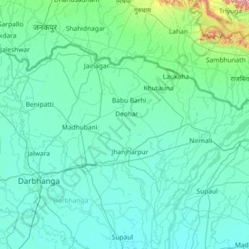
Name: Kamala River topographic map, elevation, terrain.
Location: Kamala River, Jainagar, Madhubani, Bihar, 847408, India (25.90033 86.14300 26.82908 86.35469)
Average elevation: 70 m
Minimum elevation: 39 m
Maximum elevation: 542 m
Make a donation
Other topographic maps
Click on a map to view its topography, its elevation and its terrain.
Gaya
India > Bihar > Gaya Town C.D.Block
Gaya is connected to the rest of India by roads, rail and airways. The Grand Chord section of the Indian Railways passes through Gaya. Gaya Junction railway station railway station is a major junction station serving the city. Gaya Junction has been redeveloped as Model railway station recently and houses all…
Average elevation: 111 m
Make a donation
Koshi River
The Kosi River catchment covers six geological and climatic belts varying in altitude from above 8,000 m (26,000 ft) to 95 m (312 ft) comprising the Tibetan plateau, the Himalayas, the Himalayan mid-hill belt, the Mahabharat Range, the Siwalik Hills and the Terai. The Dudh-Koshi sub-basin alone consists of 36…
Average elevation: 82 m
Make a donation
Make a donation
Make a donation
Wazirganj
Wazirganj is a historical place from time of *Alha, Udal* This is the oldest temple of Khere Wali Maiya, where Alha and Udal had arrived. Wazirganj is located at 28°13′N 79°03′E / 28.22°N 79.05°E / 28.22; 79.05. It has an average elevation of 174 metres (570 feet).
Average elevation: 111 m
Make a donation
Make a donation
Make a donation
Make a donation
Make a donation
Make a donation
Make a donation
Make a donation
Make a donation
Make a donation
Make a donation
Make a donation
Make a donation
Make a donation
Jajuara
The climate is mainly dry and cool. In summer the temperature varies from 35 °C (95 °F) to 45 °C (113 °F). In winter it is typically 5 °C (41 °F) to 15 °C (59 °F). The elevation is 51m close to sea level. The soil is suited for agriculture, which is the main economic activity of the region.
Average elevation: 53 m
Siwan
Siwan city is located at coordinates 26°13′N 84°22′E / 26.22°N 84.36°E / 26.22; 84.36 Latitude and longitude. It is counted in one of the tarai region of Himalaya Mountain range. It has an average elevation of 72 metres (236 ft). Daha River, which is a small river, which floods in rainy season…
Average elevation: 64 m
Arrah
Arrah is located at the elevation of 192 m from the sea level at the bank of Son river, Ganga River and Gangi River. Arrah lies at the confluence of the Ganga and the Son River, other small rivers that flow in the town are Gangi River, Badki Nadi and Chhotki Nadi.
Average elevation: 59 m
Make a donation
Make a donation
Make a donation
Make a donation
Make a donation
Make a donation
Make a donation