
Lohbrügge topographic map
Interactive map
Click on the map to display elevation.
About this map
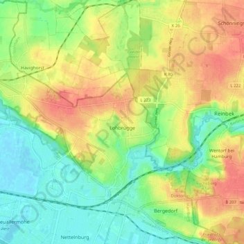
Name: Lohbrügge topographic map, elevation, terrain.
Location: Lohbrügge, Bergedorf, Hambourg, Allemagne (53.48903 10.12237 53.52642 10.22389)
Average elevation: 25 m
Minimum elevation: -2 m
Maximum elevation: 53 m
Other topographic maps
Click on a map to view its topography, its elevation and its terrain.
Fuhlsbüttel
Allemagne > Hambourg > Hambourg
Fuhlsbüttel, Hamburg-Nord, Hambourg, Allemagne
Average elevation: 19 m
Binnenalster
Allemagne > Hambourg > Hambourg
Binnenalster, Ballindamm, Hamburg-Altstadt, Hamburg-Mitte, Hambourg, 20095, Allemagne
Average elevation: 13 m
Außenalster
Außenalster, Schöne Aussicht, Uhlenhorst, Hamburg-Nord, Hambourg, 22085, Allemagne
Average elevation: 12 m
Nationalpark Hamburgisches Wattenmeer
Nationalpark Hamburgisches Wattenmeer, Wattwanderweg Neuwerk - Scharhörn, Hamburg Neuwerk, Hamburg-Mitte, Hambourg, 27499, Allemagne
Average elevation: 0 m
Bahrenfeld
Allemagne > Hambourg > Hambourg
Bahrenfeld, Altona, Hambourg, 22761, Allemagne
Average elevation: 29 m