
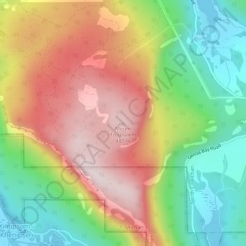
Mount Tzouhalem topographic map
Interactive map
Click on the map to display elevation.
About this map
Name: Mount Tzouhalem topographic map, elevation, terrain.
Average elevation: 233 m
Minimum elevation: 0 m
Maximum elevation: 492 m
The reserve, at middle elevations (120–280 metres) on the western side of the mountain, faces southwest and has strongly sloping, internally hilly terrain. The Tzuhalem area is a historical harvesting location for the Vancouver Island Coast Salish First Nations. The reserve is a camas harvesting site that was traditionally burned to increase yields and maintain the open, park-like habitat.
Other topographic maps
Click on a map to view its topography, its elevation and its terrain.
Stoney Hill
Canada > British Columbia > Cowichan Valley Regional District > North Cowichan
Stoney Hill, North Cowichan, Cowichan Valley Regional District, British Columbia, V9L 5T7, Canada
Average elevation: 78 m