
Make a donation
Nova Scotia topographic map
Click on the map to display elevation.
Make a donation
Nova Scotia
Nova Scotia's topography is a diverse blend of rugged highlands, rolling hills, and fertile lowlands. The province's landscape is shaped by several upland regions, including the Southern Upland, North Mountain, and Cobequid Mountain, which are interspersed with extensive lowlands. The Southern Upland rises from the Atlantic coast to elevations between 180 and 210 meters (591 to 689 feet) inland, while the North Mountain runs parallel along the Bay of Fundy, creating fertile valleys like those of the Annapolis and Cornwallis rivers. Cape Breton Island, part of Nova Scotia, features the Cape Breton Highlands, a wild, wooded plateau peaking over 550 meters (1,804 feet) above sea level, contributing to the scenic character of Cape Breton Highlands National Park. The province's coastline is heavily indented, accounting for its length of approximately 400 km (249 miles). The coast is mostly rock with small isolated sand beaches in sheltered bays. The largest coastal features include St. Margarets Bay, Halifax Harbour/Bedford Basin, Cole Harbour, Musquodoboit Harbour, Jeddore Harbour, Ship Harbour, Sheet Harbour, and Ecum Secum Harbour. The province's topography spans from lush farmland in the Musquodoboit Valley to rocky and heavily forested rolling hills. It includes a number of islands and peninsulas, among them McNabs Island, Beaver Island, Melville Island, Deadman's Island, and Sable Island. This varied terrain, combined with over 3,000 lakes and numerous rivers, creates a rich and picturesque landscape.
Make a donation
About this map
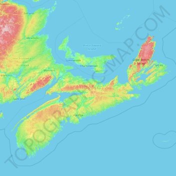
Name: Nova Scotia topographic map, elevation, terrain.
Location: Nova Scotia, Canada (43.18816 -66.68072 47.76107 -59.28871)
Average elevation: 41 m
Minimum elevation: -3 m
Maximum elevation: 746 m
Make a donation
Other topographic maps
Click on a map to view its topography, its elevation and its terrain.
Toronto
Despite its deep ravines, Toronto is not remarkably hilly, but its elevation does increase steadily away from the lake. Elevation differences range from 76.5 metres (251 ft) above sea level at the Lake Ontario shore to 209 m (686 ft) ASL near the York University grounds in the city's north end at the…
Average elevation: 113 m
Banff
Canada > Alberta > Banff > Banff
Banff is a town within Banff National Park in Alberta, Canada. It is located in Alberta's Rockies along the Trans-Canada Highway, approximately 126 km (78 mi) west of Calgary and 58 km (36 mi) east of Lake Louise. At 1,400 to 1,630 m (4,590 to 5,350 ft) above sea level, Banff is the community with the second…
Average elevation: 1,615 m
London
Canada > Ontario > London > London
London has a humid continental climate (Köppen Dfb), though due to its downwind location relative to Lake Huron and elevation changes across the city, it is virtually on the Dfa/Dfb (hot summer) boundary favouring the former climate zone to the southwest of the confluence of the South and North Thames Rivers,…
Average elevation: 268 m
Make a donation
Peterborough
Canada > Ontario > Peterborough
Peterborough's topography is largely defined by land formations created by the receding Wisconsian glaciers 10,000–15,000 years ago. The South End and Downtown portions of the City sit on what was the bottom of the glacial Lake Peterborough—part of a glacial spillway created when glacial meltwaters from…
Average elevation: 235 m
Guelph
This region of Ontario has cold winters and warm, humid summers, falling into the Köppen climate classification Dfb zone, with moderately high rainfall and snowfall. It is generally a couple of degrees cooler than lower elevation regions on the Great Lakes shorelines, especially so in winter, the exception…
Average elevation: 344 m
Make a donation
Make a donation
Hope
Canada > British Columbia > Fraser Valley Regional District > Hope > Hope
Average elevation: 435 m
Tomlinson Lake
Canada > Ontario > Thunder Bay District > Unorganized Thunder Bay District
Average elevation: 489 m
Make a donation
Lake Louise
Canada > Alberta > Improvement District No. 9
Lake Louise is a hamlet within Banff National Park in Alberta, Canada. Named after Princess Louise, Duchess of Argyll, it lies in Alberta's Rockies on the Bow River, 3 km (1.9 mi) northeast of the lake that shares its name. Initially settled in 1884 as an outpost for the Canadian Pacific Railway, Lake Louise…
Average elevation: 1,617 m
Make a donation
Burnaby
Canada > British Columbia > Metro Vancouver Regional District > Burnaby
Burnaby occupies 98.60 square kilometres (38.07 sq mi) and is located at the geographic centre of the Metro Vancouver area and home to the Metro Vancouver regional government in Metrotown. Situated between the city of Vancouver on the west and Port Moody, Coquitlam, and New Westminster on the east, Burnaby is…
Average elevation: 144 m
Make a donation
Laurentian Mountains
One of Quebec's official regions is called Laurentides. The mountain range runs through four other regions; Capitale-Nationale, Outaouais, Lanaudière, and Mauricie. The elevation generally ranges from around 500 m (1,640 ft) to 1,000 m (3,280 ft) with Mont Raoul-Blanchard being its highest peak, at 1,166 m…
Average elevation: 348 m
Make a donation
Make a donation
Grouse Mountain
Canada > British Columbia > Metro Vancouver Regional District
Grouse Mountain is one of the North Shore Mountains of the Pacific Ranges in the District Municipality of North Vancouver, British Columbia, Canada. With a maximum elevation of over 1,200 m (4,100 feet) at its peak, the mountain is the site of an alpine ski area, Grouse Mountain Resort, which overlooks Greater…
Average elevation: 968 m
Riding Mountain National Park
The climate in the Riding Mountain region is similar to that of other regions of southwestern Manitoba. Under the Köppen classification it has a continental climate. It includes grasslands, upland boreal and eastern deciduous forest ecosystems. The park has hot summers and cold winters, with annual rainfall…
Average elevation: 488 m
Make a donation
Make a donation
Mount Rundle
Canada > Alberta > Improvement District No. 9
In Banff, the Spray River trailhead for the first peak taking the Mount Rundle Trail, is near the Spray River bridge on the road to the Banff Springs Golf Course. The all-day hike (from 8–10 hours) from the trailhead to the peak is about 5 kilometres (3.1 mi) one-way and has an elevation gain of about 993…
Average elevation: 2,353 m
Make a donation
Northbrook
Canada > Ontario > Lennox and Addington County > Addington Highlands
Average elevation: 260 m
Make a donation
Celista
Canada > British Columbia > Columbia-Shuswap Regional District > Area F (Scotch Creek/Seymour Arm)
Average elevation: 407 m
Winnipeg
Canada > Manitoba > Winnipeg > Winnipeg
Winnipeg lies at the bottom of the Red River Valley, a flood plain with an extremely flat topography. It is on the eastern edge of the Canadian Prairies in Western Canada and is known as the "Gateway to the West". Winnipeg is bordered by tallgrass prairie to the west and south and the aspen parkland to the…
Average elevation: 236 m
Make a donation
Make a donation
Mission Creek Regional Park
Canada > British Columbia > Regional District of Central Okanagan > Kelowna
Average elevation: 436 m
Make a donation
Make a donation
Mount Robson
Canada > British Columbia > Regional District of Fraser-Fort George > Area H (Robson Valley/Canoe)
The north face can be seen from Berg Lake, and reached by a 19 km (11.8 mi) hike. The lake is approximately 2 km long and lies at 1,646 m (5,400 ft) elevation. There are backcountry campgrounds at each end of the lake and a log shelter on its banks, named Hargreaves Shelter in honor of the Hargreaves family…
Average elevation: 3,042 m
Mount Logan
Due to active tectonic uplifting, Mount Logan is still rising in height (approximately 0.35 mm per year). Before 1992, the exact elevation of Mount Logan was unknown and measurements ranged from 5,959 to 6,050 metres (19,551 to 19,849 ft). In May 1992, a GSC expedition climbed Mount Logan and fixed the current…
Average elevation: 5,292 m
Make a donation
Nanoose Bay
Canada > British Columbia > Regional District of Nanaimo > Area E (Nanoose Bay)
Average elevation: 58 m
Make a donation
Whistler
Canada > British Columbia > Squamish-Lillooet Regional District > Whistler Resort Municipality > Whistler
Average elevation: 996 m
Agur Lake
Canada > British Columbia > Regional District of Okanagan-Similkameen > Area F (Trout Creek Valley)
Average elevation: 1,178 m
Quebec
Canada > Quebec > Urban agglomeration of Québec
Quebec City was built on the north bank of the Saint Lawrence River, where it narrows and meets the mouth of the Saint-Charles River. Old Quebec is located on top and at the foot of Cap-Diamant, which is on the eastern edge of a plateau called the promontory of Quebec (Quebec hill). Because of this topographic…
Average elevation: 100 m
Make a donation
Make a donation
Make a donation
Mount Steele
Mount Steele is the fifth-highest mountain in Canada and either the tenth- or eleventh-highest peak in North America. Its exact elevation is uncertain. Commonly-quoted figures are 5,073 metres (16,644 ft) and 5,020 metres (16,470 ft). A lower southeast peak of Mt. Steele stands at 4,300 m (14,100 ft).
Average elevation: 4,446 m
Make a donation
Make a donation
Make a donation
Make a donation