
Thank you for supporting this site ❤️
Make a donation
Make a donation
Westfall Township topographic map
Click on the map to display elevation.
Thank you for supporting this site ❤️
Make a donation
Make a donation
About this map
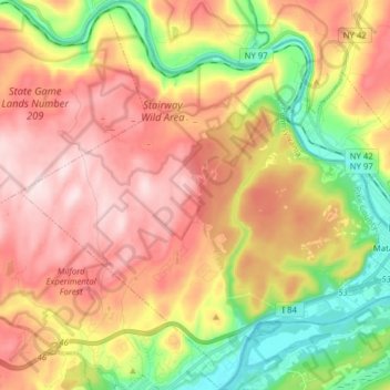
Name: Westfall Township topographic map, elevation, terrain.
Location: Westfall Township, Pike County, Pennsylvania, United States (41.32606 -74.85087 41.44290 -74.69473)
Average elevation: 287 m
Minimum elevation: 110 m
Maximum elevation: 447 m
Thank you for supporting this site ❤️
Make a donation
Make a donation
Other topographic maps
Click on a map to view its topography, its elevation and its terrain.
Hemlock Farms
United States > Pennsylvania > Pike County > Blooming Grove Township
Average elevation: 437 m
Conashaugh Lakes
United States > Pennsylvania > Pike County > Dingman Township
Average elevation: 433 m
Thank you for supporting this site ❤️
Make a donation
Make a donation
Thank you for supporting this site ❤️
Make a donation
Make a donation
Fawn Lake Forest
United States > Pennsylvania > Pike County > Lackawaxen Township
Average elevation: 380 m
Thank you for supporting this site ❤️
Make a donation
Make a donation