
Thank you for supporting this site ❤️
Make a donation
Make a donation
Serra de Monchique topographic map
Click on the map to display elevation.
Thank you for supporting this site ❤️
Make a donation
Make a donation
About this map
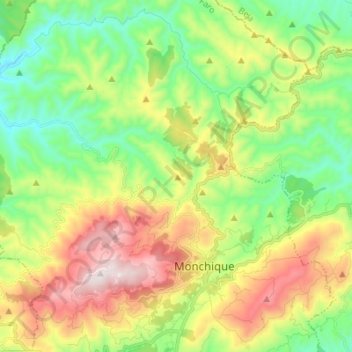
Name: Serra de Monchique topographic map, elevation, terrain.
Location: Serra de Monchique, Monchique, Faro, Portugal (37.30328 -8.65620 37.38830 -8.51921)
Average elevation: 402 m
Minimum elevation: 100 m
Maximum elevation: 894 m
Thank you for supporting this site ❤️
Make a donation
Make a donation
Other topographic maps
Click on a map to view its topography, its elevation and its terrain.
Fóia
Foia (antes do Acordo Ortográfico, Fóia) é o ponto mais alto do Algarve, situado na serra de Monchique. É acessível por estrada a partir da vila de Monchique. Tem 902 m de altitude e uma proeminência topográfica de 739 m e um isolamento topográfico de 172,69 km (o pico mais alto mais próximo é o…
Average elevation: 724 m
Thank you for supporting this site ❤️
Make a donation
Make a donation
Thank you for supporting this site ❤️
Make a donation
Make a donation