
Thank you for supporting this site ❤️
Make a donation
Make a donation
Alferce topographic map
Click on the map to display elevation.
Thank you for supporting this site ❤️
Make a donation
Make a donation
About this map
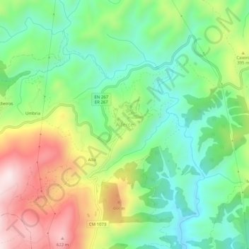
Name: Alferce topographic map, elevation, terrain.
Location: Alferce, Monchique, Faro, Portugal (37.31368 -8.50944 37.35368 -8.46944)
Average elevation: 297 m
Minimum elevation: 80 m
Maximum elevation: 654 m
Thank you for supporting this site ❤️
Make a donation
Make a donation
Other topographic maps
Click on a map to view its topography, its elevation and its terrain.