
Najran topographic map
Click on the map to display elevation.
Najran
Najran has a hot desert climate (Köppen BWh), typical of the Arabian Peninsula. Rainfall is very sporadic, and consists of light individual rainfall. Despite its location in far southern Saudi Arabia, Najran's average temperature is approximately 3.3 °C or 5.9 °F cooler than that of the Saudi capital Riyadh, due to it being 700 metres or 2,300 feet higher in altitude.
About this map
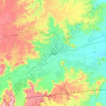
Name: Najran topographic map, elevation, terrain.
Location: Najran, Najran Region, 66261, Saudi Arabia (17.38398 44.06468 17.70398 44.38468)
Average elevation: 1,462 m
Minimum elevation: 1,211 m
Maximum elevation: 1,948 m
Other topographic maps
Click on a map to view its topography, its elevation and its terrain.