
Make a donation
Yadamah topographic map
Click on the map to display elevation.
Make a donation
About this map
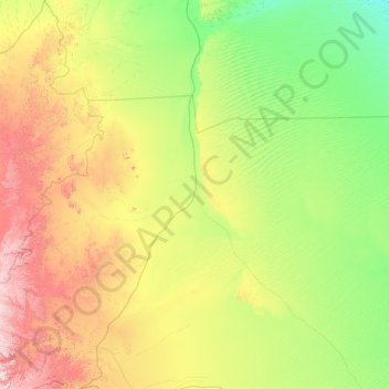
Name: Yadamah topographic map, elevation, terrain.
Location: Yadamah, Najran Region, Saudi Arabia (18.18057 43.91383 19.44889 46.53995)
Average elevation: 987 m
Minimum elevation: 595 m
Maximum elevation: 2,303 m
Make a donation
Other topographic maps
Click on a map to view its topography, its elevation and its terrain.
Najran
Najran has a hot desert climate (Köppen BWh), typical of the Arabian Peninsula. Rainfall is very sporadic, and consists of light individual rainfall. Despite its location in far southern Saudi Arabia, Najran's average temperature is approximately 3.3 °C or 5.9 °F cooler than that of the Saudi capital…
Average elevation: 1,462 m
Make a donation
Najran
Najran has a hot desert climate (Köppen BWh), typical of the Arabian Peninsula. Rainfall is very sporadic, and consists of light individual rainfall. Despite its location in far southern Saudi Arabia, Najran's average temperature is approximately 3.3 °C or 5.9 °F cooler than that of the Saudi capital…
Average elevation: 1,462 m