
Navazzo topographic map
Click on the map to display elevation.
About this map
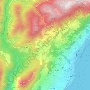
Name: Navazzo topographic map, elevation, terrain.
Average elevation: 470 m
Minimum elevation: 61 m
Maximum elevation: 984 m
Other topographic maps
Click on a map to view its topography, its elevation and its terrain.
Lake Garda
The particularly mild climate favours the growth of some hardy Mediterranean plants, including the olive tree, parasol pine, mediterranean cypress, chinese windmill palm and Canary Island Date Palm. Some hardy citrus trees, such as hardy lemons and satsuma can also be found, which are extremely rare at this…
Average elevation: 573 m
Gavardo
Gavardo, located in the lower Valle Sabbia northeast of Brescia, is the most populous town in the area. Characterized by a hilly landscape surrounded by mountains and crossed by the Chiese and Naviglio Grande Bresciano rivers. Elevation is approximately 199 m a.s.l., with the lowest point at 188 m and the…
Average elevation: 386 m