
Thank you for supporting this site ❤️
Make a donation
Make a donation
Moléson topographic map
Click on the map to display elevation.
Thank you for supporting this site ❤️
Make a donation
Make a donation
About this map
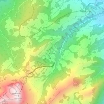
Name: Moléson topographic map, elevation, terrain.
Location: Moléson, Gruyères, Greyerzbezirk, Freiburg, 1663, Schweiz (46.54420 7.01711 46.58420 7.05711)
Average elevation: 1,256 m
Minimum elevation: 769 m
Maximum elevation: 1,976 m
Thank you for supporting this site ❤️
Make a donation
Make a donation
Other topographic maps
Click on a map to view its topography, its elevation and its terrain.
Langwiler
Schweiz > Freiburg > Greyerzbezirk
Die Fläche des 24,2 km² grossen Gemeindegebiets umfasst einen Abschnitt der Haute-Gruyère. Die Saane bildet die westliche Grenze. Von hier erstreckt sich der Gemeindeboden ostwärts über die bis zu 1,5 km breite flache Talebene, aus welcher südlich von Grandvillard die Hügel von Les Cressets aufragen.…
Average elevation: 1,203 m