
Thank you for supporting this site ❤️
Make a donation
Make a donation
Foz do Sousa topographic map
Click on the map to display elevation.
Thank you for supporting this site ❤️
Make a donation
Make a donation
About this map
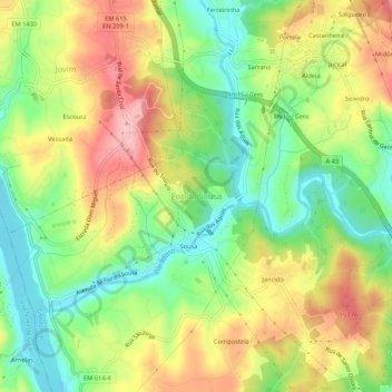
Name: Foz do Sousa topographic map, elevation, terrain.
Location: Foz do Sousa, Gondomar, Porto, 4515-184, Portugal (41.07945 -8.51991 41.11945 -8.47991)
Average elevation: 78 m
Minimum elevation: 1 m
Maximum elevation: 171 m
Thank you for supporting this site ❤️
Make a donation
Make a donation
Other topographic maps
Click on a map to view its topography, its elevation and its terrain.
Thank you for supporting this site ❤️
Make a donation
Make a donation
Thank you for supporting this site ❤️
Make a donation
Make a donation
Thank you for supporting this site ❤️
Make a donation
Make a donation