
Thank you for supporting this site ❤️
Make a donation
Make a donation
Melres e Medas topographic map
Click on the map to display elevation.
Thank you for supporting this site ❤️
Make a donation
Make a donation
About this map
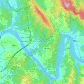
Name: Melres e Medas topographic map, elevation, terrain.
Location: Melres e Medas, Gondomar, Porto, Portugal (41.03564 -8.46558 41.09775 -8.37257)
Average elevation: 108 m
Minimum elevation: 5 m
Maximum elevation: 406 m
Thank you for supporting this site ❤️
Make a donation
Make a donation
Other topographic maps
Click on a map to view its topography, its elevation and its terrain.
Thank you for supporting this site ❤️
Make a donation
Make a donation
Thank you for supporting this site ❤️
Make a donation
Make a donation
Thank you for supporting this site ❤️
Make a donation
Make a donation
Thank you for supporting this site ❤️
Make a donation
Make a donation
Thank you for supporting this site ❤️
Make a donation
Make a donation
Thank you for supporting this site ❤️
Make a donation
Make a donation