
Thank you for supporting this site ❤️
Make a donation
Make a donation
Silver Lake topographic map
Click on the map to display elevation.
Thank you for supporting this site ❤️
Make a donation
Make a donation
About this map
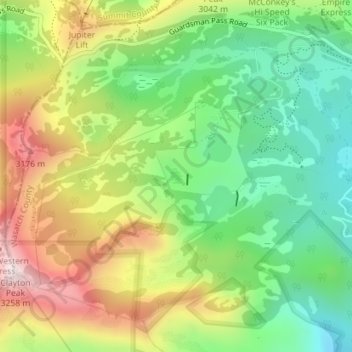
Name: Silver Lake topographic map, elevation, terrain.
Location: Silver Lake, Wasatch County, Utah, United States (40.59757 -111.54420 40.59857 -111.54317)
Average elevation: 2,893 m
Minimum elevation: 2,635 m
Maximum elevation: 3,254 m
Thank you for supporting this site ❤️
Make a donation
Make a donation
Other topographic maps
Click on a map to view its topography, its elevation and its terrain.
Thank you for supporting this site ❤️
Make a donation
Make a donation
Thank you for supporting this site ❤️
Make a donation
Make a donation