
Iringa topographic map
Interactive map
Click on the map to display elevation.
About this map
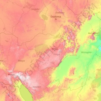
Name: Iringa topographic map, elevation, terrain.
Location: Iringa, Southern Highlands Zone, Tanzanie (-10.33427 32.92263 -5.21427 38.04263)
Average elevation: 1,024 m
Minimum elevation: 54 m
Maximum elevation: 2,910 m
La ville est située dans une région éloignée des grandes villes, sur les hautes terres du centre du pays. À 1 550 m d'altitude, elle connaît un climat généralement frais, avec parfois des températures nocturnes proches de 0 °C en hiver (juin-août). C'est une des villes les plus élevées du pays.
Other topographic maps
Click on a map to view its topography, its elevation and its terrain.