
Washington County topographic map
Interactive map
Click on the map to display elevation.
About this map
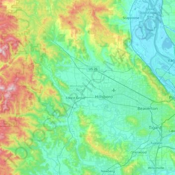
Name: Washington County topographic map, elevation, terrain.
Location: Washington County, Oregon, United States (45.31720 -123.48606 45.78016 -122.74251)
Average elevation: 213 m
Minimum elevation: -3 m
Maximum elevation: 1,063 m
Other topographic maps
Click on a map to view its topography, its elevation and its terrain.
Portland
United States > Oregon > Multnomah County
Portland, Multnomah County, Oregon, United States
Average elevation: 77 m
Salem
United States > Oregon > Marion County
Salem, Marion County, Oregon, United States
Average elevation: 96 m
Eugene
United States > Oregon > Lane County
Eugene, Lane County, Oregon, United States
Average elevation: 163 m
Redmond
United States > Oregon > Deschutes County
Redmond, Deschutes County, Oregon, 91156, United States
Average elevation: 923 m
Bend
United States > Oregon > Deschutes County
Bend, Deschutes County, Oregon, United States
Average elevation: 1,121 m
Ashland
United States > Oregon > Jackson County
Ashland, Jackson County, Oregon, United States
Average elevation: 774 m
Grants Pass
United States > Oregon > Josephine County
Grants Pass, Josephine County, Oregon, United States
Average elevation: 374 m
Corvallis
United States > Oregon > Benton County
Corvallis, Benton County, Oregon, United States
Average elevation: 81 m
Klamath Falls
United States > Oregon > Klamath County
Klamath Falls, Klamath County, Oregon, 97601, United States
Average elevation: 1,312 m
Roseburg
United States > Oregon > Douglas County
Roseburg, Douglas County, Oregon, United States
Average elevation: 239 m
La Pine
United States > Oregon > Deschutes County
La Pine, Deschutes County, Oregon, 97739, United States
Average elevation: 1,290 m
McMinnville
United States > Oregon > Yamhill County
McMinnville, Yamhill County, Oregon, 97128, United States
Average elevation: 50 m
Florence
United States > Oregon > Lane County
Florence, Lane County, Oregon, United States
Average elevation: 22 m
Newport
United States > Oregon > Lincoln County
Newport, Lincoln County, Oregon, United States
Average elevation: 33 m
Astoria
United States > Oregon > Clatsop County
Astoria, Clatsop County, Oregon, 97103, United States
Average elevation: 15 m
Lincoln City
United States > Oregon > Lincoln County
Lincoln City, Lincoln County, Oregon, United States
Average elevation: 47 m
Hood River
United States > Oregon > Hood River County
Hood River, Hood River County, Oregon, United States
Average elevation: 112 m
Newberg
United States > Oregon > Yamhill County
Newberg, Yamhill County, Oregon, United States
Average elevation: 61 m
Oregon City
United States > Oregon > Clackamas County
Oregon City, Clackamas County, Oregon, 97045, United States
Average elevation: 99 m
Albany
United States > Oregon > Linn County
Albany, Linn County, Oregon, United States
Average elevation: 71 m
Lake Oswego
United States > Oregon > Clackamas County
Lake Oswego, Clackamas County, Oregon, United States
Average elevation: 87 m
Anns Butte
United States > Oregon > Deschutes County
Anns Butte, Deschutes County, Oregon, United States
Average elevation: 1,312 m
Hillsboro
United States > Oregon > Washington County
Hillsboro, Washington County, Oregon, United States
Average elevation: 53 m
Gresham
United States > Oregon > Multnomah County
Gresham, Multnomah County, Oregon, United States
Average elevation: 90 m
Bandon
United States > Oregon > Coos County
Bandon, Coos County, Oregon, United States
Average elevation: 22 m
Prineville
United States > Oregon > Crook County
Prineville, Crook County, Oregon, United States
Average elevation: 928 m
Dairy
United States > Oregon > Klamath County
Dairy, Klamath County, Oregon, 97625, United States
Average elevation: 1,300 m
Pine Grove
United States > Oregon > Wasco County
Pine Grove, Wasco County, Oregon, United States
Average elevation: 713 m
Silver Falls State Park
United States > Oregon > Marion County
Silver Falls State Park, Marion County, Oregon, United States
Average elevation: 551 m
Willamette River
United States > Oregon > Polk County
Willamette River, Polk County, Oregon, United States
Average elevation: 72 m
Silverton
United States > Oregon > Marion County
Silverton, Marion County, Oregon, 97381, United States
Average elevation: 103 m
West Linn
United States > Oregon > Clackamas County
West Linn, Clackamas County, Oregon, 97068, United States
Average elevation: 74 m
Estacada
United States > Oregon > Clackamas County
Estacada, Clackamas County, Oregon, 97023, United States
Average elevation: 176 m
Tigard
United States > Oregon > Washington County
Tigard, Washington County, Oregon, United States
Average elevation: 83 m
Brookings
United States > Oregon > Curry County
Brookings, Curry County, Oregon, 97415, United States
Average elevation: 131 m
Sunriver
United States > Oregon > Deschutes County
Sunriver, Deschutes County, Oregon, 97707, United States
Average elevation: 1,312 m
Pendleton
United States > Oregon > Umatilla County
Pendleton, Umatilla County, Oregon, 97801, United States
Average elevation: 402 m
Trail
United States > Oregon > Jackson County
Trail, Jackson County, Oregon, 97539, United States
Average elevation: 534 m
Mount Hood National Forest
Mount Hood National Forest, Oregon, United States
Average elevation: 794 m
Neahkahnie Beach
United States > Oregon > Tillamook County
Neahkahnie Beach, Tillamook County, Oregon, United States
Average elevation: 101 m
Saint Helens
United States > Oregon > Columbia County
Saint Helens, Columbia County, Oregon, 97051, United States
Average elevation: 27 m
Milwaukie
United States > Oregon > Clackamas County
Milwaukie, Clackamas County, Oregon, 97222, United States
Average elevation: 49 m
Sheridan
United States > Oregon > Yamhill County
Sheridan, Yamhill County, Oregon, United States
Average elevation: 85 m
Graveyard Point
United States > Oregon > Curry County > Port Orford
Graveyard Point, Port Orford, Curry County, Oregon, 97465, United States
Average elevation: 17 m
Chickahominy Reservoir
United States > Oregon > Harney County
Chickahominy Reservoir, Harney County, Oregon, United States
Average elevation: 1,310 m
Sherwood
United States > Oregon > Washington County
Sherwood, Washington County, Oregon, 97140, United States
Average elevation: 68 m