
Eugene topographic map
Click on the map to display elevation.
Eugene
Eugene is characterized by a varied topography that contributes to its picturesque landscapes. The city sits at an average elevation of about 426 feet (130 meters) and is nestled within the Willamette Valley, surrounded by the foothills of the Cascade Mountains to the east, which rise significantly in elevation, peaking at over 10,000 feet (3,048 meters) nearby. This valley is defined by gently rolling hills and low-lying areas, interspersed with numerous rivers and streams, including the Willamette River, which flows through the city. The region experiences a mild climate and abundant rainfall, fostering lush vegetation and rich biodiversity, making it a haven for outdoor enthusiasts who enjoy hiking and other recreational activities in the surrounding natural areas.
About this map
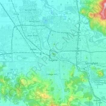
Name: Eugene topographic map, elevation, terrain.
Location: Eugene, Lane County, Oregon, United States (43.98753 -123.20876 44.13232 -123.03059)
Average elevation: 163 m
Minimum elevation: 88 m
Maximum elevation: 689 m
Other topographic maps
Click on a map to view its topography, its elevation and its terrain.
Thurston Hills Natural Area
United States > Oregon > Lane County > Springfield
Average elevation: 324 m