
Burlington topographic map
Interactive map
Click on the map to display elevation.
About this map
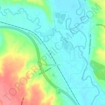
Name: Burlington topographic map, elevation, terrain.
Location: Burlington, Ward County, North Dakota, United States (48.26798 -101.43586 48.28886 -101.41161)
Average elevation: 500 m
Minimum elevation: 475 m
Maximum elevation: 555 m
Other topographic maps
Click on a map to view its topography, its elevation and its terrain.
Minot
United States > North Dakota > Ward County
Minot, Ward County, North Dakota, United States
Average elevation: 510 m
Kenmare
United States > North Dakota > Ward County
Kenmare, Ward County, North Dakota, United States
Average elevation: 577 m
Sawyer
United States > North Dakota > Ward County
Sawyer, Ward County, North Dakota, United States
Average elevation: 488 m
Berthold
United States > North Dakota > Ward County > Berthold
Berthold, Ward County, North Dakota, United States
Average elevation: 634 m