
Thank you for supporting this site ❤️
Make a donation
Make a donation
Minot topographic map
Click on the map to display elevation.
Thank you for supporting this site ❤️
Make a donation
Make a donation
Minot
The elevation of the river at the city center is 1,540 feet (470 m) above sea level. The valley sits 160 feet (49 m) below the surrounding plains; the elevation at the Minot International Airport on North Hill is 1,716 feet (523 m). The city has several small horseshoe-shaped oxbow lakes within its limits near the river, created by the Mouse's meandering course.
Thank you for supporting this site ❤️
Make a donation
Make a donation
About this map
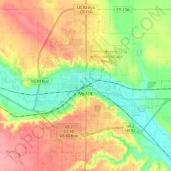
Name: Minot topographic map, elevation, terrain.
Location: Minot, Ward County, North Dakota, United States (48.18953 -101.36125 48.28743 -101.17831)
Average elevation: 511 m
Minimum elevation: 467 m
Maximum elevation: 564 m
Thank you for supporting this site ❤️
Make a donation
Make a donation