
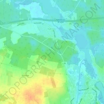
Nahmitz topographic map
Interactive map
Click on the map to display elevation.
About this map
Name: Nahmitz topographic map, elevation, terrain.
Average elevation: 40 m
Minimum elevation: 28 m
Maximum elevation: 67 m
Other topographic maps
Click on a map to view its topography, its elevation and its terrain.
Rietz
Deutschland > Brandenburg > Potsdam-Mittelmark > Kloster Lehnin
Rietz, Kloster Lehnin, Potsdam-Mittelmark, Brandenburg, Deutschland
Average elevation: 32 m
Göhlsdorf
Deutschland > Brandenburg > Potsdam-Mittelmark > Kloster Lehnin > Göhlsdorf
Göhlsdorf, Kloster Lehnin, Potsdam-Mittelmark, Brandenburg, Deutschland
Average elevation: 47 m
Lehnin
Deutschland > Brandenburg > Potsdam-Mittelmark > Kloster Lehnin
Lehnin, Kloster Lehnin, Potsdam-Mittelmark, Brandenburg, Deutschland
Average elevation: 49 m