
Thank you for supporting this site ❤️
Make a donation
Make a donation
Riggs topographic map
Click on the map to display elevation.
Thank you for supporting this site ❤️
Make a donation
Make a donation
About this map
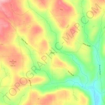
Name: Riggs topographic map, elevation, terrain.
Location: Riggs, Bradford County, Pennsylvania, United States (41.81813 -76.59606 41.85813 -76.55606)
Average elevation: 389 m
Minimum elevation: 304 m
Maximum elevation: 461 m
Thank you for supporting this site ❤️
Make a donation
Make a donation
Other topographic maps
Click on a map to view its topography, its elevation and its terrain.
Lake Wesauking
United States > Pennsylvania > Bradford County > Wysox Township
Average elevation: 355 m
Thank you for supporting this site ❤️
Make a donation
Make a donation
Thank you for supporting this site ❤️
Make a donation
Make a donation
Thank you for supporting this site ❤️
Make a donation
Make a donation