
Make a donation
Lower Allen topographic map
Click on the map to display elevation.
Make a donation
About this map
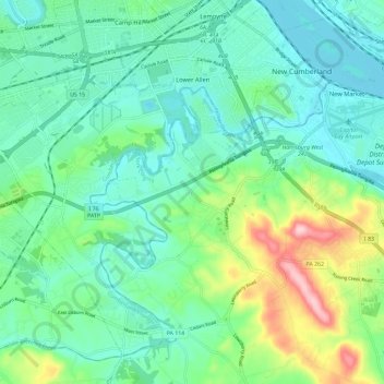
Name: Lower Allen topographic map, elevation, terrain.
Location: Lower Allen, Cumberland County, Pennsylvania, United States (40.16234 -76.98468 40.23833 -76.86796)
Average elevation: 144 m
Minimum elevation: 86 m
Maximum elevation: 319 m
Make a donation
Other topographic maps
Click on a map to view its topography, its elevation and its terrain.
Doubling Gap
United States > Pennsylvania > Cumberland County > Lower Mifflin Township
Average elevation: 373 m
Heron Pond
United States > Pennsylvania > Cumberland County > Penn Township > Huntsdale
Average elevation: 198 m
Middlesex
United States > Pennsylvania > Cumberland County > Middlesex Township
Average elevation: 137 m
Walnut Bottom
United States > Pennsylvania > Cumberland County > South Newton Township
Average elevation: 229 m
Make a donation
Wertzville
United States > Pennsylvania > Cumberland County > Silver Spring Township
Average elevation: 165 m
West Hill
United States > Pennsylvania > Cumberland County > West Pennsboro Township
Average elevation: 149 m
Williams Grove
United States > Pennsylvania > Cumberland County > Monroe Township
Average elevation: 148 m
Summerdale
United States > Pennsylvania > Cumberland County > East Pennsboro Township
Average elevation: 160 m
Make a donation
Sporting Hill
United States > Pennsylvania > Cumberland County > Hampden Township
Average elevation: 125 m
Shepherdstown
United States > Pennsylvania > Cumberland County > Upper Allen Township
Average elevation: 153 m
Hogestown
United States > Pennsylvania > Cumberland County > Silver Spring Township
Average elevation: 126 m
Make a donation
Grantham
United States > Pennsylvania > Cumberland County > Upper Allen Township
Average elevation: 150 m
Entlerville
United States > Pennsylvania > Cumberland County > Upper Frankford Township
Average elevation: 257 m
Caprivi
United States > Pennsylvania > Cumberland County > North Middleton Township
Average elevation: 156 m
Bowmansdale
United States > Pennsylvania > Cumberland County > Upper Allen Township
Average elevation: 153 m
Make a donation
Bloserville
United States > Pennsylvania > Cumberland County > Upper Frankford Township
Average elevation: 185 m
New Kingstown
United States > Pennsylvania > Cumberland County > Silver Spring Township
Average elevation: 137 m
Boiling Springs
United States > Pennsylvania > Cumberland County > South Middleton Township
Average elevation: 162 m
Make a donation
Pine Grove Furnace
United States > Pennsylvania > Cumberland County > Cooke Township
Average elevation: 332 m
Greason
United States > Pennsylvania > Cumberland County > West Pennsboro Township
Average elevation: 155 m
Rosegarden
United States > Pennsylvania > Cumberland County > Upper Allen Township
Average elevation: 143 m
Sunset Rocks
United States > Pennsylvania > Cumberland County > Cooke Township
Average elevation: 357 m
Make a donation
Lewis Rocks
United States > Pennsylvania > Cumberland County > Southampton Township
Average elevation: 462 m