
Rülzheim topographic map
Interactive map
Click on the map to display elevation.
About this map
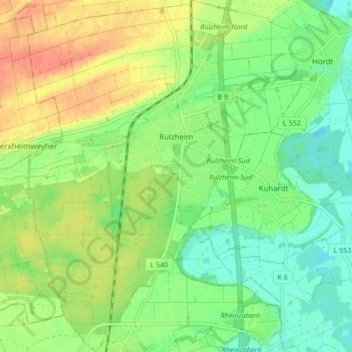
Name: Rülzheim topographic map, elevation, terrain.
Average elevation: 118 m
Minimum elevation: 99 m
Maximum elevation: 147 m
Einige Tabaktrockenschuppen (Lage)49.1629438.282876 erinnern an den Tabakanbau des 19. und 20. Jahrhunderts in Rülzheim und Umgebung. Rülzheim ist Namensgeber des sogenannten Rülzheimer Schuppens; dabei handelt es sich um einen langen, etwa drei bis vier Meter hohen Holzschuppen mit einem flachen Satteldach. Dieser Schuppentyp kam in den 1970er Jahren auf; ältere Schuppen waren meist kürzer, aber deutlich höher. Einige Exemplare des Rülzheimer Schuppens haben sich rund 300 m nördlich des Bahnhofs erhalten.
Other topographic maps
Click on a map to view its topography, its elevation and its terrain.
76771
Deutschland > Rheinland-Pfalz > Landkreis Germersheim > Hördt
76771, Hördt, Rülzheim, Landkreis Germersheim, Rheinland-Pfalz, Deutschland
Average elevation: 102 m
Wörth am Rhein
Deutschland > Rheinland-Pfalz > Landkreis Germersheim
Wörth am Rhein, Landkreis Germersheim, Rheinland-Pfalz, 76744, Deutschland
Average elevation: 115 m
Germersheim
Deutschland > Rheinland-Pfalz > Landkreis Germersheim
Germersheim, Landkreis Germersheim, Rheinland-Pfalz, 76726, Deutschland
Average elevation: 104 m
Kandel
Deutschland > Rheinland-Pfalz > Landkreis Germersheim
Kandel, Landkreis Germersheim, Rheinland-Pfalz, Deutschland
Average elevation: 124 m
Schaidt
Deutschland > Rheinland-Pfalz > Landkreis Germersheim > Wörth am Rhein
Schaidt, Wörth am Rhein, Landkreis Germersheim, Rheinland-Pfalz, Deutschland
Average elevation: 146 m
Winden
Deutschland > Rheinland-Pfalz > Landkreis Germersheim
Winden, Kandel, Landkreis Germersheim, Rheinland-Pfalz, Deutschland
Average elevation: 146 m
Jockgrim
Deutschland > Rheinland-Pfalz > Landkreis Germersheim
Jockgrim, Landkreis Germersheim, Rheinland-Pfalz, 76751, Deutschland
Average elevation: 109 m
Maximiliansau
Deutschland > Rheinland-Pfalz > Landkreis Germersheim > Wörth am Rhein
Maximiliansau, Wörth am Rhein, Landkreis Germersheim, Rheinland-Pfalz, 76767, Deutschland
Average elevation: 106 m
Leimersheim
Deutschland > Rheinland-Pfalz > Landkreis Germersheim
Leimersheim, Rülzheim, Landkreis Germersheim, Rheinland-Pfalz, 76774, Deutschland
Average elevation: 101 m
Hagenbach
Deutschland > Rheinland-Pfalz > Landkreis Germersheim
Hagenbach, Landkreis Germersheim, Rheinland-Pfalz, 76767, Deutschland
Average elevation: 110 m
Bellheim
Deutschland > Rheinland-Pfalz > Landkreis Germersheim
Bellheim, Landkreis Germersheim, Rheinland-Pfalz, 76756, Deutschland
Average elevation: 119 m
Schwegenheim
Deutschland > Rheinland-Pfalz > Landkreis Germersheim
Schwegenheim, Lingenfeld, Landkreis Germersheim, Rheinland-Pfalz, 67365, Deutschland
Average elevation: 115 m
Berg (Pfalz)
Deutschland > Rheinland-Pfalz > Landkreis Germersheim > Berg (Pfalz)
Berg (Pfalz), Hagenbach, Landkreis Germersheim, Rheinland-Pfalz, 76768, Deutschland
Average elevation: 115 m
Rheinzabern
Deutschland > Rheinland-Pfalz > Landkreis Germersheim
Rheinzabern, Jockgrim, Landkreis Germersheim, Rheinland-Pfalz, 76764, Deutschland
Average elevation: 112 m
Westheim
Deutschland > Rheinland-Pfalz > Landkreis Germersheim
Westheim, Lingenfeld, Landkreis Germersheim, Rheinland-Pfalz, 67368, Deutschland
Average elevation: 114 m
Hördt
Deutschland > Rheinland-Pfalz > Landkreis Germersheim
Hördt, Rülzheim, Landkreis Germersheim, Rheinland-Pfalz, 76771, Deutschland
Average elevation: 107 m
Lingenfeld
Deutschland > Rheinland-Pfalz > Landkreis Germersheim
Lingenfeld, Landkreis Germersheim, Rheinland-Pfalz, 67360, Deutschland
Average elevation: 110 m