
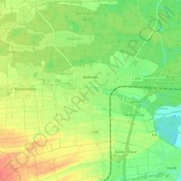
Bellheim topographic map
Interactive map
Click on the map to display elevation.
About this map
Name: Bellheim topographic map, elevation, terrain.
Average elevation: 119 m
Minimum elevation: 95 m
Maximum elevation: 147 m
Bellheim ist Standort von zehn Windkraftanlagen; zwei Anlagen mit 600 kW-Leistung wurden 2001, drei weitere Anlagen mit je 1500 kW-Leistung und fünf mit 2000 kW-Leistung wurden 2009 installiert. Die Anlage bei 49° 10′ 31,6″ N, 8° 15′ 36,7″ O49.1754444444448.2601944444444 hat eine Gesamthöhe von 139 Metern, ebenso die Anlagen bei 49° 10′ 27,1″ N, 8° 15′ 46,5″ O49.1742027777788.2629083333333, und 49° 10′ 24,2″ N, 8° 16′ 7,9″ O49.1733916666678.2688638888889.
Other topographic maps
Click on a map to view its topography, its elevation and its terrain.
76771
Deutschland > Rheinland-Pfalz > Landkreis Germersheim > Hördt
76771, Hördt, Rülzheim, Landkreis Germersheim, Rheinland-Pfalz, Deutschland
Average elevation: 102 m
Wörth am Rhein
Deutschland > Rheinland-Pfalz > Landkreis Germersheim
Wörth am Rhein, Landkreis Germersheim, Rheinland-Pfalz, 76744, Deutschland
Average elevation: 115 m
Germersheim
Deutschland > Rheinland-Pfalz > Landkreis Germersheim
Germersheim, Landkreis Germersheim, Rheinland-Pfalz, 76726, Deutschland
Average elevation: 104 m
Kandel
Deutschland > Rheinland-Pfalz > Landkreis Germersheim
Kandel, Landkreis Germersheim, Rheinland-Pfalz, Deutschland
Average elevation: 124 m
Schaidt
Deutschland > Rheinland-Pfalz > Landkreis Germersheim > Wörth am Rhein
Schaidt, Wörth am Rhein, Landkreis Germersheim, Rheinland-Pfalz, Deutschland
Average elevation: 146 m
Winden
Deutschland > Rheinland-Pfalz > Landkreis Germersheim
Winden, Kandel, Landkreis Germersheim, Rheinland-Pfalz, Deutschland
Average elevation: 146 m
Jockgrim
Deutschland > Rheinland-Pfalz > Landkreis Germersheim
Jockgrim, Landkreis Germersheim, Rheinland-Pfalz, 76751, Deutschland
Average elevation: 109 m
Maximiliansau
Deutschland > Rheinland-Pfalz > Landkreis Germersheim > Wörth am Rhein
Maximiliansau, Wörth am Rhein, Landkreis Germersheim, Rheinland-Pfalz, 76767, Deutschland
Average elevation: 106 m
Leimersheim
Deutschland > Rheinland-Pfalz > Landkreis Germersheim
Leimersheim, Rülzheim, Landkreis Germersheim, Rheinland-Pfalz, 76774, Deutschland
Average elevation: 101 m
Hagenbach
Deutschland > Rheinland-Pfalz > Landkreis Germersheim
Hagenbach, Landkreis Germersheim, Rheinland-Pfalz, 76767, Deutschland
Average elevation: 110 m
Schwegenheim
Deutschland > Rheinland-Pfalz > Landkreis Germersheim
Schwegenheim, Lingenfeld, Landkreis Germersheim, Rheinland-Pfalz, 67365, Deutschland
Average elevation: 115 m
Berg (Pfalz)
Deutschland > Rheinland-Pfalz > Landkreis Germersheim > Berg (Pfalz)
Berg (Pfalz), Hagenbach, Landkreis Germersheim, Rheinland-Pfalz, 76768, Deutschland
Average elevation: 115 m
Rheinzabern
Deutschland > Rheinland-Pfalz > Landkreis Germersheim
Rheinzabern, Jockgrim, Landkreis Germersheim, Rheinland-Pfalz, 76764, Deutschland
Average elevation: 112 m
Westheim
Deutschland > Rheinland-Pfalz > Landkreis Germersheim
Westheim, Lingenfeld, Landkreis Germersheim, Rheinland-Pfalz, 67368, Deutschland
Average elevation: 114 m
Hördt
Deutschland > Rheinland-Pfalz > Landkreis Germersheim
Hördt, Rülzheim, Landkreis Germersheim, Rheinland-Pfalz, 76771, Deutschland
Average elevation: 107 m
Rülzheim
Deutschland > Rheinland-Pfalz > Landkreis Germersheim
Rülzheim, Landkreis Germersheim, Rheinland-Pfalz, 76761, Deutschland
Average elevation: 118 m
Lingenfeld
Deutschland > Rheinland-Pfalz > Landkreis Germersheim
Lingenfeld, Landkreis Germersheim, Rheinland-Pfalz, 67360, Deutschland
Average elevation: 110 m