
Thank you for supporting this site ❤️
Make a donation
Make a donation
Genelle topographic map
Click on the map to display elevation.
Thank you for supporting this site ❤️
Make a donation
Make a donation
About this map
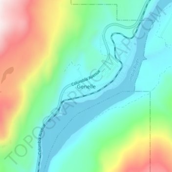
Name: Genelle topographic map, elevation, terrain.
Average elevation: 656 m
Minimum elevation: 406 m
Maximum elevation: 1,304 m
Thank you for supporting this site ❤️
Make a donation
Make a donation
Other topographic maps
Click on a map to view its topography, its elevation and its terrain.
Rossland Range Recreation Site
Canada > British Columbia > Regional District of Kootenay Boundary > Area B (Lower Columbia/Old Glory)
Average elevation: 1,452 m