
浪茄灣 topographic map
Interactive map
Click on the map to display elevation.
About this map
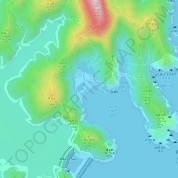
Name: 浪茄灣 topographic map, elevation, terrain.
Location: 浪茄灣, 西貢區, 新界, 香港, 中国 (22.37257 114.37483 22.37571 114.37814)
Average elevation: 70 m
Minimum elevation: -10 m
Maximum elevation: 296 m
Other topographic maps
Click on a map to view its topography, its elevation and its terrain.