
Spring Gulch topographic map
Interactive map
Click on the map to display elevation.
About this map
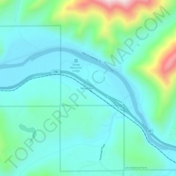
Name: Spring Gulch topographic map, elevation, terrain.
Location: Spring Gulch, Mineral County, Montana, United States (47.21021 -115.00069 47.25021 -114.96069)
Average elevation: 926 m
Minimum elevation: 798 m
Maximum elevation: 1,427 m
Other topographic maps
Click on a map to view its topography, its elevation and its terrain.
Quartz
United States > Montana > Mineral County
Quartz, Mineral County, Montana, United States
Average elevation: 979 m
Alberton
United States > Montana > Mineral County
Alberton, Mineral County, Montana, United States
Average elevation: 1,099 m
St. Regis
United States > Montana > Mineral County > St. Regis
St. Regis, Mineral County, Montana, 59866, United States
Average elevation: 840 m
Haugan
United States > Montana > Mineral County > Haugan
Haugan, Mineral County, Montana, United States
Average elevation: 1,044 m