
Thank you for supporting this site ❤️
Make a donation
Make a donation
Watkins Pond topographic map
Click on the map to display elevation.
Thank you for supporting this site ❤️
Make a donation
Make a donation
About this map
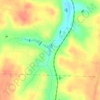
Name: Watkins Pond topographic map, elevation, terrain.
Location: Watkins Pond, Burke County, Georgia, United States (33.20020 -81.98559 33.20348 -81.98243)
Average elevation: 78 m
Minimum elevation: 43 m
Maximum elevation: 103 m
Thank you for supporting this site ❤️
Make a donation
Make a donation
Other topographic maps
Click on a map to view its topography, its elevation and its terrain.