
华蓥市 topographic map
Interactive map
Click on the map to display elevation.
About this map
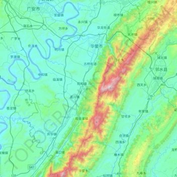
Name: 华蓥市 topographic map, elevation, terrain.
Location: 华蓥市, 广安市, 四川省, 中国 (30.12017 106.60350 30.47562 106.90463)
Average elevation: 459 m
Minimum elevation: 201 m
Maximum elevation: 1,653 m
华蓥山又名称西山,古称华银山,是川中丘陵和川东平行岭谷的天然界山,山脉呈东北至西南走向,北起大巴山南麓达州市境内的万源市南部,南延至重庆永川黄瓜山,纵跨四川、重庆两省市的15个县(市、区),延绵300余公里,有九峰山、缙云山和中梁山3条支脉。山势东缓西陡,平均海拔800米~1000米,主峰高登山海拔1704.1米,为四川盆地底部最高峰;次峰宝鼎位于华蓥山中段、现华蓥市溪口镇境内,海拔1586米,是川东佛教圣地,享有“川东峨眉”的美誉。
Other topographic maps
Click on a map to view its topography, its elevation and its terrain.