
Bethlehem Township topographic map
Interactive map
Click on the map to display elevation.
About this map
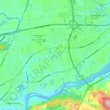
Name: Bethlehem Township topographic map, elevation, terrain.
Average elevation: 119 m
Minimum elevation: 60 m
Maximum elevation: 310 m
Other topographic maps
Click on a map to view its topography, its elevation and its terrain.
Middletown
United States > Pennsylvania > Northampton County > Bethlehem Township > Butztown
Middletown, Butztown, Bethlehem Township, Northampton County, Pennsylvania, United States
Average elevation: 103 m
Butztown
United States > Pennsylvania > Northampton County > Bethlehem Township
Butztown, Bethlehem Township, Northampton County, Pennsylvania, 18020, United States
Average elevation: 110 m
Green Pond
United States > Pennsylvania > Northampton County > Bethlehem Township
Green Pond, Bethlehem Township, Northampton County, Pennsylvania, United States
Average elevation: 124 m