
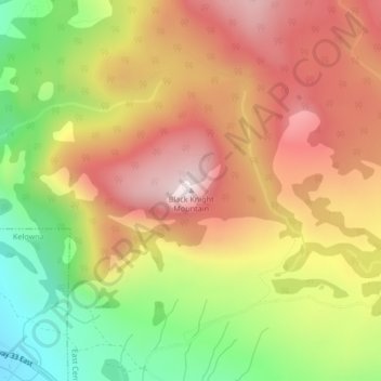
Black Knight Mountain topographic map
Interactive map
Click on the map to display elevation.
About this map
Name: Black Knight Mountain topographic map, elevation, terrain.
Average elevation: 992 m
Minimum elevation: 654 m
Maximum elevation: 1,278 m
Other topographic maps
Click on a map to view its topography, its elevation and its terrain.
Hydraulic Lake
Canada > British Columbia > Regional District of Central Okanagan > East Central Okanagan Electoral Area
Hydraulic Lake, East Central Okanagan Electoral Area, Regional District of Central Okanagan, British Columbia, Canada
Average elevation: 1,266 m
Little White Mountain
Canada > British Columbia > Regional District of Central Okanagan > East Central Okanagan Electoral Area
Little White Mountain, East Central Okanagan Electoral Area, Regional District of Central Okanagan, British Columbia, Canada
Average elevation: 1,935 m
Oyama Lake
Canada > British Columbia > Regional District of Central Okanagan > East Central Okanagan Electoral Area
Oyama Lake, East Central Okanagan Electoral Area, Regional District of Central Okanagan, British Columbia, Canada
Average elevation: 1,387 m
Browne Lake
Canada > British Columbia > Regional District of Central Okanagan > East Central Okanagan Electoral Area
Browne Lake, East Central Okanagan Electoral Area, Regional District of Central Okanagan, British Columbia, Canada
Average elevation: 1,326 m
Damer Lake
Canada > British Columbia > Regional District of Central Okanagan > East Central Okanagan Electoral Area
Damer Lake, East Central Okanagan Electoral Area, Regional District of Central Okanagan, British Columbia, Canada
Average elevation: 1,353 m