
晋江市 topographic map
Interactive map
Click on the map to display elevation.
About this map
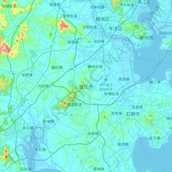
Name: 晋江市 topographic map, elevation, terrain.
Location: 晋江市, 泉州市, 晋江市, 福建省, 中国 (24.62444 118.38775 24.94444 118.70775)
Average elevation: 32 m
Minimum elevation: -4 m
Maximum elevation: 529 m
晉江位於北緯24°30′-24°54′,東經118°24′-118°43′,地處福建四大河流之一晉江南岸,東與石獅市接壤,東面瀕臨台灣海峽,西與南安市交界,北與泉州鯉城區相鄰,南與金門島隔海相望。全市陸域面積649平方公里。 晉江全境地形比較平緩,主要以平原和丘陵為主。平原主要位於東北部靠近泉州灣和西南部圍頭灣一帶。丘陵則大小分佈在各個地方,海拔均比較低。海拔較高的山峰有北部紫帽山和中部靈源山。晉江最高點在紫帽山,海拔517.8米。
Other topographic maps
Click on a map to view its topography, its elevation and its terrain.