
Tochal topographic map
Interactive map
Click on the map to display elevation.
Tochal
Tochal (Persian: توچال Točāl), is a mountain and ski resort located on the Alborz mountain range, adjacent to the metropolitan area of Tehran in northern Iran. It includes a 12-kilometre-long (7.5 mi) ridge. Its highest peak, also called Tochal, is at an elevation of 3,964 metres (13,005 ft).
About this map
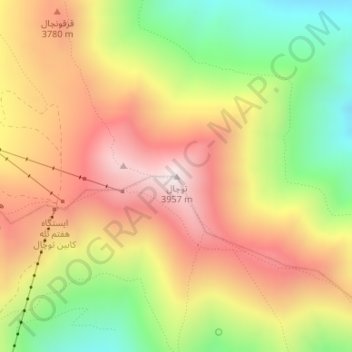
Name: Tochal topographic map, elevation, terrain.
Location: Tochal, رودبار قصران, Shemiranat County, Tehran Province, Iran (35.88430 51.41982 35.88440 51.41992)
Average elevation: 3,562 m
Minimum elevation: 3,122 m
Maximum elevation: 3,958 m
Other topographic maps
Click on a map to view its topography, its elevation and its terrain.