
Make a donation
Luke topographic map
Click on the map to display elevation.
Make a donation
About this map
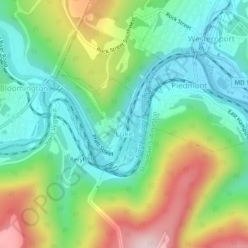
Name: Luke topographic map, elevation, terrain.
Location: Luke, Allegany County, Maryland, 21540, United States (39.47069 -79.06693 39.48156 -79.05366)
Average elevation: 401 m
Minimum elevation: 271 m
Maximum elevation: 653 m
Make a donation
Other topographic maps
Click on a map to view its topography, its elevation and its terrain.
Make a donation
Zihlman
United States > Maryland > Allegany County
Zihlman is located along Maryland Route 36, 1.5 miles (2.4 km) northeast of and 500 feet (150 m) lower in elevation than Frostburg. Mount Savage is 3 miles (5 km) further northeast along MD 36.
Average elevation: 590 m
Make a donation
Make a donation
Make a donation
Make a donation
Lavale Community Park
United States > Maryland > Allegany County > Allegany Grove
Average elevation: 354 m
Make a donation
Make a donation
Make a donation
Make a donation
County Fairgrounds
United States > Maryland > Allegany County > Potomac Park > Cedar Cliff
Average elevation: 274 m
Make a donation
Mount Savage
United States > Maryland > Allegany County
A small blue-collar community, Mount Savage lies at the base of Big Savage Mountain in the Allegheny Mountains, between the cities of Frostburg and Cumberland. It began as a small farming settlement in the mid-19th century, but it was not until 1844 that the region was put on the nation's map with the pressing…
Average elevation: 476 m
Make a donation
Cumberland Heights
United States > Maryland > Allegany County > Cumberland > Cumberland Heights
Average elevation: 214 m
Lucas Heights
United States > Maryland > Allegany County > La Vale > Lucas Heights
Average elevation: 373 m