
Thank you for supporting this site ❤️
Make a donation
Make a donation
Amcelle topographic map
Click on the map to display elevation.
Thank you for supporting this site ❤️
Make a donation
Make a donation
About this map
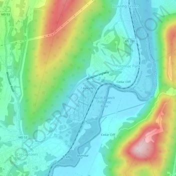
Name: Amcelle topographic map, elevation, terrain.
Average elevation: 291 m
Minimum elevation: 187 m
Maximum elevation: 563 m
Thank you for supporting this site ❤️
Make a donation
Make a donation
Other topographic maps
Click on a map to view its topography, its elevation and its terrain.
County Fairgrounds
United States > Maryland > Allegany County > Potomac Park > Cedar Cliff
Average elevation: 274 m