
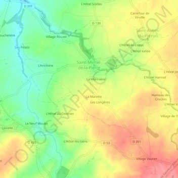
Saint-Michel-de-la-Pierre topographic map
Interactive map
Click on the map to display elevation.
About this map
Name: Saint-Michel-de-la-Pierre topographic map, elevation, terrain.
Average elevation: 68 m
Minimum elevation: 25 m
Maximum elevation: 110 m
Other topographic maps
Click on a map to view its topography, its elevation and its terrain.
Le Mesnil Yserand
France > Normandie > Manche > Saint-Sauveur-Villages > La Ronde-Haye
Le Mesnil Yserand, La Ronde-Haye, Saint-Sauveur-Villages, Coutances, Manche, Normandie, France métropolitaine, 50490, France
Average elevation: 47 m
La Troudière
France > Normandie > Manche > Saint-Sauveur-Villages > Le Mesnilbus > La Troudière
La Troudière, Le Mesnilbus, Saint-Sauveur-Villages, Coutances, Manche, Normandie, France métropolitaine, 50490, France
Average elevation: 70 m
La Commanderie
France > Normandie > Manche > Saint-Sauveur-Villages > Le Mesnilbus
La Commanderie, Le Mesnilbus, Saint-Sauveur-Villages, Coutances, Manche, Normandie, France métropolitaine, 50490, France
Average elevation: 77 m
Lastelle
France > Normandie > Manche > Saint-Sauveur-Villages > Saint-Sauveur-Lendelin
Lastelle, Saint-Sauveur-Lendelin, Saint-Sauveur-Villages, Coutances, Manche, Normandie, France métropolitaine, 50490, France
Average elevation: 65 m
Le Mesnilbus
France > Normandie > Manche > Saint-Sauveur-Villages
Le Mesnilbus, Saint-Sauveur-Villages, Coutances, Manche, Normandie, France métropolitaine, 50490, France
Average elevation: 77 m
La Patinière
France > Normandie > Manche > Saint-Sauveur-Villages > Le Mesnilbus
La Patinière, Le Mesnilbus, Saint-Sauveur-Villages, Coutances, Manche, Normandie, France métropolitaine, 50490, France
Average elevation: 77 m
Ancteville
France > Normandie > Manche > Saint-Sauveur-Villages
Ancteville, Saint-Sauveur-Villages, Coutances, Manche, Normandie, France métropolitaine, 50200, France
Average elevation: 73 m
Saint-Sauveur-Lendelin
France > Normandie > Manche > Saint-Sauveur-Villages
Saint-Sauveur-Lendelin, Saint-Sauveur-Villages, Coutances, Manche, Normandie, France métropolitaine, 50490, France
Average elevation: 65 m
Saint-Aubin-du-Perron
France > Normandie > Manche > Saint-Sauveur-Villages
Saint-Aubin-du-Perron, Saint-Sauveur-Villages, Coutances, Manche, Normandie, France métropolitaine, 50490, France
Average elevation: 54 m