
Thank you for supporting this site ❤️
Make a donation
Make a donation
Christina Lake topographic map
Click on the map to display elevation.
Thank you for supporting this site ❤️
Make a donation
Make a donation
About this map
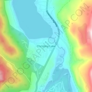
Name: Christina Lake topographic map, elevation, terrain.
Average elevation: 588 m
Minimum elevation: 439 m
Maximum elevation: 977 m
Thank you for supporting this site ❤️
Make a donation
Make a donation
Other topographic maps
Click on a map to view its topography, its elevation and its terrain.
Christina Lake
Canada > British Columbia > Regional District of Kootenay Boundary > Area C (Christina Lake) > Christina Lake
Average elevation: 1,062 m