
Adorf/Vogtland topographic map
Interactive map
Click on the map to display elevation.
About this map
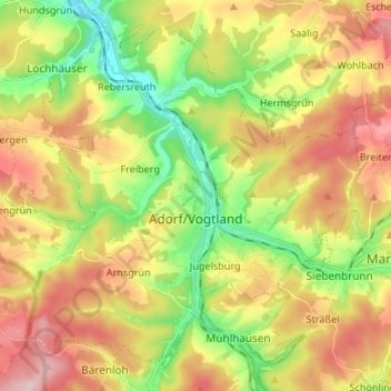
Name: Adorf/Vogtland topographic map, elevation, terrain.
Location: Adorf/Vogtland, Vogtlandkreis, Sachsen, 08626, Deutschland (50.28822 12.17608 50.36328 12.30987)
Average elevation: 531 m
Minimum elevation: 412 m
Maximum elevation: 666 m
Other topographic maps
Click on a map to view its topography, its elevation and its terrain.
Reichenbach
Deutschland > Sachsen > Vogtlandkreis
Reichenbach, Reichenbach im Vogtland, Vogtlandkreis, Sachsen, Deutschland
Average elevation: 401 m
Posseck
Deutschland > Sachsen > Vogtlandkreis
Posseck, Triebel, Verwaltungsgemeinschaft Oelsnitz/Vogtl., Vogtlandkreis, Sachsen, 08606, Deutschland
Average elevation: 571 m
Plauen
Deutschland > Sachsen > Vogtlandkreis
Plauen, Vogtlandkreis, Sachsen, Deutschland
Average elevation: 429 m