
Ifni Lake topographic map
Interactive map
Click on the map to display elevation.
About this map
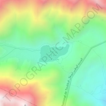
Name: Ifni Lake topographic map, elevation, terrain.
Average elevation: 2,593 m
Minimum elevation: 2,123 m
Maximum elevation: 3,344 m
Other topographic maps
Click on a map to view its topography, its elevation and its terrain.
Atlas Mountains
Morocco > cercle de Taliouine > Toubkal ⵜⵓⴱⵇⴰⵍ توبقال
Atlas Mountains, Toubkal ⵜⵓⴱⵇⴰⵍ توبقال, caïdat de’Ouzioua, cercle de Taliouine, Taroudant Province, Souss-Massa, Morocco
Average elevation: 3,402 m