
Bern topographic map
Interactive map
Click on the map to display elevation.
About this map
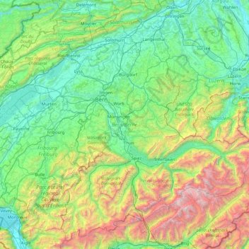
Name: Bern topographic map, elevation, terrain.
Location: Bern, Switzerland (46.32652 6.86148 47.34531 8.45516)
Average elevation: 1,131 m
Minimum elevation: 360 m
Maximum elevation: 4,158 m
Other topographic maps
Click on a map to view its topography, its elevation and its terrain.
Dents du Midi
Switzerland > Wallis > Monthey > Val-d'Illiez
The Dents du Midi are situated on the border between the communes of Val-d'Illiez and Evionnaz. The north face rises above the Val d'Illiez while the south face overlooks the Lac de Salanfe, an artificial reservoir. The ridge of the chain is situated at an altitude varying between 2,997 and 3,258 meters (9,833…
Average elevation: 2,440 m
Kiental
Switzerland > Bern > Frutigen-Niedersimmental administrative district > Reichenbach im Kandertal
Average elevation: 1,363 m
Zernez
Switzerland > Grisons > Region Engiadina Bassa/Val Müstair > Zernez > Zernez
Lai da Ova Spin is a compensation reservoir on the river Spöl. It is located in the upper areas of the Lower Engadine valley (Romansh: Engiadina Bassa). It is located at an elevation of 1,473 m (4,833 ft) and is connected to the railway network of the Rhätische Bahn. In Zernez, the stream Spöl empties into…
Average elevation: 1,789 m