
Thank you for supporting this site ❤️
Make a donation
Make a donation
Scugog topographic map
Click on the map to display elevation.
Thank you for supporting this site ❤️
Make a donation
Make a donation
About this map
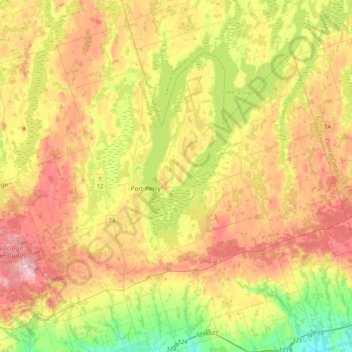
Name: Scugog topographic map, elevation, terrain.
Location: Scugog, Durham Region, Golden Horseshoe, Ontario, Canada (44.00924 -79.12249 44.22235 -78.70321)
Average elevation: 274 m
Minimum elevation: 159 m
Maximum elevation: 404 m
Thank you for supporting this site ❤️
Make a donation
Make a donation
Other topographic maps
Click on a map to view its topography, its elevation and its terrain.
Thank you for supporting this site ❤️
Make a donation
Make a donation
Darlington Provincial Park
Canada > Ontario > Durham Region > Clarington
Darlington Provincial Park is a provincial park in Ontario, Canada. It is located just south of Highway 401 in the city of Bowmanville. A small park, the topography is dominated by gentle hills formed by a terminal moraine deposited by glaciers at the end of the last Ice Age. The park borders on the northern…
Average elevation: 84 m
Thank you for supporting this site ❤️
Make a donation
Make a donation
Thank you for supporting this site ❤️
Make a donation
Make a donation
Thank you for supporting this site ❤️
Make a donation
Make a donation
Thank you for supporting this site ❤️
Make a donation
Make a donation
Thank you for supporting this site ❤️
Make a donation
Make a donation
Thank you for supporting this site ❤️
Make a donation
Make a donation
Thank you for supporting this site ❤️
Make a donation
Make a donation
Thank you for supporting this site ❤️
Make a donation
Make a donation
Thank you for supporting this site ❤️
Make a donation
Make a donation
Thank you for supporting this site ❤️
Make a donation
Make a donation