
Dar es Salaam topographic map
Interactive map
Click on the map to display elevation.
About this map
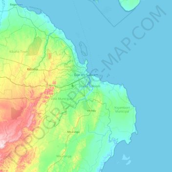
Name: Dar es Salaam topographic map, elevation, terrain.
Location: Dar es Salaam, Coastal Zone, Tanzania (-7.18684 39.00703 -6.56620 39.92805)
Average elevation: 57 m
Minimum elevation: 0 m
Maximum elevation: 387 m
Other topographic maps
Click on a map to view its topography, its elevation and its terrain.
Arusha
Despite its proximity to the equator, Arusha's elevation of 1,400 metres (4,600 ft) on the southern slopes of Mount Meru keeps temperatures relatively low and alleviates humidity. Cool dry air is prevalent for much of the year. The temperature typically ranges between 10 and 30 °C (50 and 86 °F) with an…
Average elevation: 1,572 m
Dodoma
Tanzania > Dodoma Region > Dodoma
The official capital since 1996, Dodoma was envisaged as the first non-monumental capital city as opposed to the monumentality and hierarchy of other planned capital cities such as Abuja, Brasília and Washington, D.C. It rejected geometrical forms such as grid iron and radial plans as inappropriate as the…
Average elevation: 1,145 m