
Make a donation
Bras de la Ravine Sèche topographic map
Click on the map to display elevation.
Make a donation
About this map
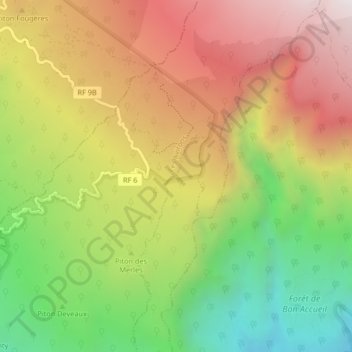
Name: Bras de la Ravine Sèche topographic map, elevation, terrain.
Average elevation: 1,592 m
Minimum elevation: 925 m
Maximum elevation: 2,256 m
Make a donation
Other topographic maps
Click on a map to view its topography, its elevation and its terrain.
Le Tevelave
France > La Réunion > Les Avirons > La Chapelle
Situé à 900 mètres d'altitude, sur le versant sud-ouest de l'île, le village est adossé à la forêt et fait face à l'océan Indien en de superbes panoramas.
Average elevation: 890 m
Make a donation
Le Tevelave
France > La Réunion > Les Avirons > La Chapelle
Situé à 900 mètres d'altitude, sur le versant sud-ouest de l'île, le village est adossé à la forêt et fait face à l'océan Indien en de superbes panoramas.
Average elevation: 890 m
Le Tevelave
France > La Réunion > Les Avirons > La Chapelle
Situé à 900 mètres d'altitude, sur le versant sud-ouest de l'île, le village est adossé à la forêt et fait face à l'océan Indien en de superbes panoramas.
Average elevation: 890 m