
Union Grove topographic map
Interactive map
Click on the map to display elevation.
About this map
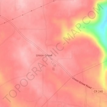
Name: Union Grove topographic map, elevation, terrain.
Location: Union Grove, Marshall County, Alabama, United States (34.39586 -86.45835 34.40841 -86.44003)
Average elevation: 299 m
Minimum elevation: 174 m
Maximum elevation: 328 m
Union Grove is located in western Marshall County at 34°24′0″N 86°26′46″W / 34.40000°N 86.44611°W / 34.40000; -86.44611 (34.400088, -86.446049). It is 7 miles (11 km) northeast of Arab and 5 miles (8 km) southwest of Guntersville Dam on the Tennessee River. Union Grove sits at an elevation of 1,040 feet (320 m) above sea level on the relatively flat top of Brindley Mountain, near the southwest end of the Appalachian Plateau. Electricity service in Union Grove is provided through Arab Electric Cooperative, which comes through the Tennessee Valley Authority.
Other topographic maps
Click on a map to view its topography, its elevation and its terrain.
Guntersville
United States > Alabama > Marshall County
Guntersville, Marshall County, Alabama, 35976, United States
Average elevation: 242 m
Needmore
United States > Alabama > Marshall County
Needmore, Marshall County, Alabama, United States
Average elevation: 294 m
Albertville
United States > Alabama > Marshall County
Albertville, Marshall County, Alabama, 35950, United States
Average elevation: 309 m
Bucksnort
United States > Alabama > Marshall County
Bucksnort, Marshall County, Alabama, 35747, United States
Average elevation: 289 m
Union Grove
United States > Alabama > Marshall County > Union Grove
Union Grove, Marshall County, Alabama, United States
Average elevation: 300 m
Lake Guntersville State Park
United States > Alabama > Marshall County > Guntersville
Lake Guntersville State Park, Guntersville, Marshall County, Alabama, United States
Average elevation: 242 m
Grant
United States > Alabama > Marshall County
Grant, Marshall County, Alabama, 35847, United States
Average elevation: 300 m
Shoal Creek
United States > Alabama > Marshall County > Arab
Shoal Creek, Arab, Marshall County, Alabama, 35016, United States
Average elevation: 327 m
Lindsay Lane
United States > Alabama > Marshall County > Guntersville
Lindsay Lane, Guntersville, Marshall County, Alabama, 35976, United States
Average elevation: 249 m
Boaz
United States > Alabama > Marshall County
Boaz, Marshall County, Alabama, 35957, United States
Average elevation: 320 m
Wyeth City
United States > Alabama > Marshall County > Guntersville > Wyeth City
Wyeth City, Guntersville, Marshall County, Alabama, 35976, United States
Average elevation: 230 m
Guntersville
United States > Alabama > Marshall County > Guntersville
Guntersville, Marshall County, Alabama, 35976, United States
Average elevation: 208 m
Bob Mountain
United States > Alabama > Marshall County
Bob Mountain, Marshall County, Alabama, United States
Average elevation: 206 m
Arab
United States > Alabama > Marshall County
Arab, Marshall County, Alabama, 35016, United States
Average elevation: 314 m